Presagis is a Montreal-based software company that supplies the top 100 defense and aeronautic companies in the world with simulation and graphics software. Over the last decade, Presagis has built a strong reputation in helping create the complexity of the real world in a virtual one. Their deep understanding of the defense and aeronautic industries combined with expertise in synthetic environments, simulation & visualization, human-machine interfaces, and sensors positions them to meet today’s goals and prepare for tomorrow’s challenges. Today, Presagis is heavily investing into the research and innovation of virtual reality, artificial intelligence, and big data analysis. By leveraging their experience and recognizing emerging trends, their pioneering team of experts, former military personnel, and programmers are challenging the status quo and building tomorrow’s technology — today.
La ville de Terrebonne telle qu’on la connaît aujourd’hui est issue de la fusion en 2001 des municipalités de Terrebonne, de Lachenaie et de La Plaine. Terrebonne est la dixième ville en importance du Québec. Son territoire s’étend au total sur près de 160 km2 avec une longueur avec 27,8 km entre son point le plus à l’est et son point le plus à l’ouest. La municipalité est traversée du nord au sud par les autoroutes 25 et 40, soit deux axes structurants pour les villes de la couronne nord de Montréal, et plus généralement pour les régions administratives des Laurentides et de Lanaudière. En étant située entre Laval et l’Est de Montréal et en zone limitrophe des Basses-Laurentides, Terrebonne jouit d’une localisation stratégique qui offre un fort potentiel de développement économique. Par ailleurs, Terrebonne est bordée par la belle richesse naturelle qu’offre la rivière des Mille-Îles. La municipalité vise l’atteinte d’un bon équilibre entre son côté nature et son côté urbain au profit d’un milieu de vie sain pour ses citoyens.

The Immersive and Creative Technologies lab (ICT lab) was established in late 2011 as a premier research lab, committed to fostering academic excellence, groundbreaking research, and innovative solutions within the field of Computer Science. Our talented team of researchers concentrate on specialized areas such as computer vision, computer graphics, virtual/augmented reality, and creative technologies, while exploring their applications across a diverse array of disciplines. At the ICT Lab, we strive to achieve ambitious long-term objectives that are centered around the development of highly realistic virtual environments. Our primary objectives include (a) creating virtual worlds that are virtually indistinguishable from the real-world locations they represent, and (b) employing these sophisticated digital twins to produce a wide range of impactful visualizations for various applications. Through our dedication to academic rigor, inventive research, and creative problem-solving, we aim to propel the boundaries of technological innovation and contribute to the advancement of human knowledge.
Shubham Rajeev Punekar - Concordia (PhD)
Naghmeh Shafiee Roudbari - Concordia (PhD) [graduated]
Viktoriya Markutsa - Concordia (MSc) - [graduated]
Yashas Joshi - Concordia (PhD) - [graduated]
Anh Phuong Tran - Ville de Terrebonne (Architecte de solutions)
Philippe Hamel - Ville de Terrebonne (Chef de section, sécurité organisationnelle et réseautique)
Rémi Asselin - Ville de Terrebonne (Directeur, Direction des technologies de l'information)
Sacha Lepretre - Presagis Inc (CTO)
Charalambos Poullis - Concordia (PI)
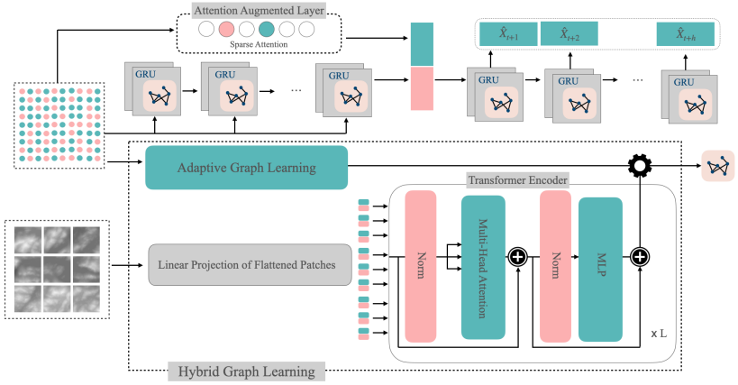
Computational Fluid Dynamics
AI-based Fluid
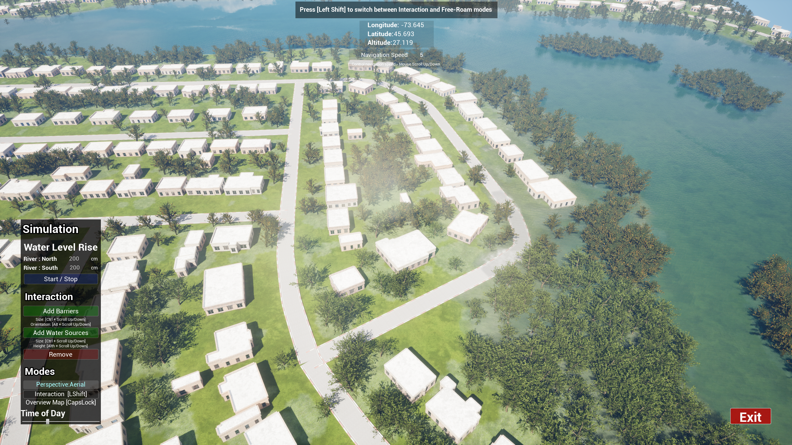
Simulating Floods for Risk Assessment and Evaluation of Countermeasures.
Charalambos Poullis
Immersive and Creative Technologies Lab
Department of Computer Science and Software Engineering
Concordia University
1455 de Maisonneuve Blvd. West, ER 925,
Montréal, Québec,
Canada, H3G 1M8
Copyright © 2022 Immersive and Creative Technologies lab, Concordia University. All Right Reserved